

Digital mapping is a form of mapping in which ground data is collected and converted into a virtual image containing all the information about the land. It is a kind of digital map, which provides complete and accurate information of a particular place. Over time, paper maps become more difficult to maintain because of the fear of spoilage. On the contrary, managing digitally generated maps is a very simple task. Digital maps can be updated with the help of satellites as the development of global positioning system technology has made this possible.
The Punjab Government continues
to implement projects under new schemes for the welfare of the farmers. The
most innovative of these schemes is called 'Digital Mapping'. This scheme will
be of great benefit to the farmers as the use of this technology will help the
farmers in locating their land and the farmers will be able to easily identify
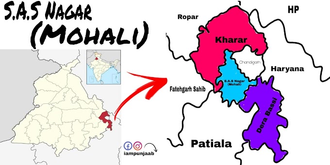
the demarcation of their land. This project was first started in two villages
of District SAS Nagar (formerly Mohali) of Punjab so that the work of
demarcation of land boundary in both the villages could be done easily with the
help of 'Digital Mapping'. The use of this project in the age of technology
would help the land owners to find their land easily. This project has been
initiated by the Revenue Department of Punjab.
The Revenue Department of Punjab
is planning on a digital method of land demarcation as well as other methods.
In this way, demarcation of land boundary is being planned. The major
beneficiaries of the digital mapping project will be the landowners. With the
help of this great success will be achieved in resolving land disputes between
land owners and the real owner of the land will easily know the extent of his
land. With the commencement of this scheme the disputes among the landowners
would be reduced. The government led by Punjab Chief Minister Mr. Partap Singh
Kairon had also set up pillars for demarcation of land boundaries but at
present they are not in a good condition to carry out land demarcation work.
Under the pilot project, two
villages of Mohali district have been selected by the Revenue Department of the
Punjab Government. The work of land demarcation 'Digital Mapping' project has
been started in two villages Mundi Kharar and Harlalpur of Mohali district. The
digitally generated map will clearly show the land markings. The digital map
will clearly show the line of the Mustal, the line of the killa, the number of
the Mustil, the number of the killa, the line of reference, the land pillars.
Digital mapping will be done with the help of space satellites and pre-made
maps. It will now take very little time for anyone to get information about the
demarcation of their land and the information will be easily accessible.


0 Comments